
A House That Still Exists in Orbit: Satellite Capabilities

Generated graphic of objects in Earth’s orbit, 95% of which are orbital debris. (NASA 2019a)
It’s easy to forget how much of our world depends on what’s orbiting above it, and this doesn’t just mean for defence, navigation, communication or agriculture, which we often think of satellites as tools for, but also for history.
Recently, my late grandparents’ house was demolished, a place where many childhood memories were made and where their lives unfolded. Realising it wasn’t a place you could drive past anymore when missing them was a difficult moment, yet opening Google Earth and using the historical imagery to go back to when it still stood was a comforting ability.
It was one of those moments that made you genuinely appreciate the capabilities of our world’s technology, technology that makes tools like Google Earth Possible. Not only their house, but so much of the world’s history is preserved quietly from above as earth observation captures a collection of images of life unfolding across the planet.
The vast network of satellites orbiting Earth is what makes moments like these possible, capturing and documenting how the planet evolves over time. The imagery we see is a compilation of data from a number of satellite programs, including NASA’s Landsat Program, the Copernicus Program, the US National Agriculture Imagery Program (NAIP), and the Moderate Resolution Imaging Spectroradiometer (MODIS) sensors on NASA's Terra and Aqua satellites, along with contributions from many other companies. (Earth Engine Data Catalog n.d.)
“Google Earth is the biggest repository of geo-imagery, the most photorealistic digital version of our planet.”
The Landsat program is a series of satellites that provide Google Earth with multispectral and thermal captures of the Earth's entire surface approximately once every two weeks at a 30-meter resolution. Landsat has been mapping Earth for just over 53 years, since 1972, building a visual record of Earth’s history. These satellites provide a 2D global view on Google Earth, contributing around 700,000 images that are updated once every couple of years. (Earth Engine Data Catalog n.d.)
The further you zoom in, the more frequently the images are refreshed, particularly in population-dense regions, which may be updated as often as less than 12 months.
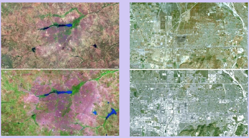
Landsat capture, left; comparison image of Ouagadougou, Burkina Faso, right; comparison image of Ontario, California. (NASA 2019)
The Sentinel Satellites from the European Space Agency’s (ESA) Copernicus Program complement these Landsat observations with weather radar images, high-resolution optical images, and ocean and land data, providing the finer details. For instance, Sentinel-2 captures Earth in 13 spectral bands for in-depth perspectives on vegetation and land. (European Space Agency 2024)
Looking closer in, the 3D data we see is created by stitching together images captured by cameras mounted on planes that fly in zig-zag paths over areas of interest. These mapping flights can take several hours, generally a 5-hour process, and the overlapping images are combined using photogrammetry, a method that constructs the 3D models by comparing different perspectives of the same locations. This is the purpose of the zig-zag path and the multiple cameras, as it allows us to capture varied angles. (Google Earth’s Incredible 3D Imagery, Explained n.d.)

NASA's Ikhana aircraft, on a wildfire imaging mission. (NASA 2019)
This process creates a mosaic of images built through automated and manual corrections to colour, lighting, and angles, along with removal of clouds and even objects like cars to produce the clean imagery we see online.
Earth observation faces a number of challenges, with weather being the biggest. Clear skies are ideal hence why it can take multiple satellite passes and flights to capture the preferred images for a single location. (Google Earth’s Incredible 3D Imagery, Explained n.d.)
Beneficially, this effort contributes to tracking the planets evolution and as mentioned means satellites play a major role in agriculture, science, defence and navigation. However, they also serve as a preservation of Earth’s timeline, which for some can mean the ability to study the melting of icecaps, deforestation, or population density, or observe a coastline that over time has eroded and changed shape, and for others the personal capabilities such as revisiting a house that no longer stands.
Satellites are recording the life of earth as it continuously changes, and to consider that billions of dollars’ worth of technology designed for defensive, scientific and environmental earth monitoring purposes can also capture something so personal holds a unique beauty. As satellite technology continues to advance, our ability to understand, protect and even remember our world will only improve, ensuring that as the planet evolves, it’s history will be preserved, existing in orbit.
-
Earth Engine Data Catalog n.d., Google Developers.
European Space Agency 2024, Sentinel-2, www.esa.int.
Google Earth’s Incredible 3D Imagery, Explained n.d., www.youtube.com.
NASA 2019a, ARES | Orbital Debris Program Office | Photo Gallery, Nasa.gov.
NASA 2019, NASA Image and Video Library, Nasa.gov.